Tuesday, July 31, 2012


I am excited to be recognized by the Master of Public Health as having one of the 25 best sites for healthy living.
This list of 25 blogs has 7 sites for yoga, 10 for running, and 8 for healthy eating.
There was no danger of me ending up in one of those other categories, as I can barely bend over and look at my toes, and I seem to understand healthy eating as having a big appetite.
To view this health site, click on the Top Healthy Lifestyle Site to the right. ~~~~>

Monday, July 30, 2012

The TOTs invade the Wildwoods of Chandler Park


Despite dealing with hellacious horrifying hideous hammering horrendous heat, our TOT runs have never let up. Sunday morning, as I drove to Chandler Park at 6:30, I noticed the reading on my car said the outside temp was 88°, a record for the warmest low temp ever in Oklahoma. I guess however, it must have been one degree cooler at the airport, where official records are kept, so the actual record did not fall. (That record DID fall the next day when the official reading was 88° for the low.)
But do these gurlz look hot? (well, yes they do. Just ask Mitch!)

So a little after 7:30 22 of us broke into 2 groups, and toted plenty of water and Gatorade with us around the hills and valleys, canyons and streams dry creek beds in the wildwoods west of Chandler Park Proper. Who would dare to go beyond the gate?? They all did! Twelve went with me, taking a winding yet deliberate route through steeply descending single-track mountain bike trailz, rugged jeep roads, sharp climbs up the side of never-ending hills only to descend and ascend again. Can you say "hillwork?" But the pace was easy, and the conversation good. My leading skills were never criticized, although I thought I felt a muttering of curse words directed towards me--or maybe it was at a pesky horsefly?

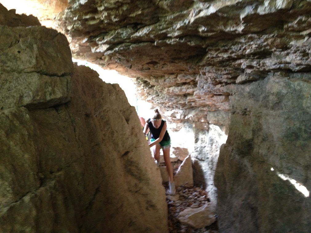
After the ups and downs and ups, we came to a series of spectacular rock outcroppings. The whole line of trail runners ventured through the keyhole to the other side.

It was a scramble--watch your step, watch your head, watch for snakes Actually, it didn't seem that snaky, but one never knows for sure.

Ruben seems glad to have made it through unscathed. I am glad he's back running with us.

Mitch stops to examine something. It seems as though he's staring at skeletal remains of something(one), or maybe he just had gas?

Rachel seemed to be having a blast. She and Christina soaked in every square inch of the scenery along the way. From a recent Facebook post, I think I have helped her become more acquainted with a foam roller. (Just trying to help! :-) )

We had the pleasure of Rafael running with us. There is no need for an iPod when Rafael comes along. He provides non-stop entertainment, complete with segments of health information and coaching, IRS horror stories, tails of Florida and Miami beaches, interludes of reminders that we Okies don't know what humidity is, and on this trip, an account of him meeting the love of his life. Rafael MUST be my pacer in a 100 someday. We trade insults back and forth more than the Hatfields and McCoys, and his exuberant dialogue on the totality of life might be enough to keep me awake when I'm fighting falling asleep on my feet at mile 75. And lest you think I am complaining, I actually enjoyed the run with him.

We are entering some of the tallest bluffs and rocks in this part of the state. I truly believe that this could be a state park, but I'm quite happy for it to remain undeveloped.

Rachel took this pic, and it has been said that I demonstrate my zombie traits here. I have no idea what I was saying (or thinking) at this point.

There are several slots passing from one chamber to another. Each of these rock faces are excellent for climbing and/or rappelling. A few climbers come here, but it looked like non had been here in a while.

Pausing for one more group picture, we headed back to the parking area. Yes, there were more hills, but we seemed to move along a little faster. I think we got stronger as we went.

Rafael, Krystal, and I headed out for another 3 miles after refueling, They finished with 7 miles, and I with 8.2 due to a short warm-up before everyone got to the park. Stormy's group enjoyed the Powerline Trail, which is an insane roller coaster of jeep roads with about 500 feet of climb. They spilled into a neighborhood, and opted to "road it" on back. We lost no one, and I've heard a couple of remarks hinting of a return trip. Good times.

Friday, July 27, 2012

Happy birthday to me


My little brother Fiver shared this on my timeline for my birthday. This is an amazing video, and is just exactly what I would like to be doing today/tonight. Fiver is not a runner, although he looks more like a runner than I do. Maybe he'll come over to the dark side someday.
Onwards from AKQA on Vimeo.
What a great present, yes?

Greeting from Tulsa Hills

Thursday, July 26, 2012

Sunday TOT Run Preview


I'm excited to be sharing some awesome trailz in the Chandler Park Wildwoods this Sunday!! The TOTs will meet at Chandler park instead of the usual Turkey Mountain for 3-8 miles on a mostly unused trail system.
I marked off a 3 mile course today, which has no bad climbs, no water crossings, but plenty of rocks and roots, and almost mystical rock outcroppings. I marked the course with aqua tape--like the pic above. Look for small tabs at all the intersections and a confidence tab every 100-200 yards.

There are some narrow single track trailz here, but this out-and-back with a big loop at the end is mostly wider trail.

A half mile in, you'll travel through a small channel through some rocks. This is cool, but would be an amazing night run. Anyone game??

There are a couple of downhills, followed by a couple of uphills. Nothing as bad as Lipbuster on this portion, although on the other course which runs west has a couple of ridiculously steep nasty climbs. I'll post more on that tomorrow.

Watch for the blue-green (aqua) tape tabs. This is probably the worst uphill--no, the one in the next pic is about 3/4 mile later and is slightly steeper.

After this climb, you cross the corner of a big clearing.

Watch for tape tabs directing you to the right. It is easy to miss this turn, and going straight or left will take you miles and miles away from where you need to go--unless you actually want a 10 mile run.

You re-enter the woods, and follow the trail until it intersects with a trail you were on earlier, and then you follow the tape tabs back to where you started.

Back through the walled channels. Take your time to notice the trees growing right out of the sides of these rocks. There are many openings in the rocks where monsters could hide at night.

Enter at your own peril. This looks like a time portal to me.

There are several caves here. It's amazing how many times I ran through here and never noticed them.

And the rocks through here have personality. Watch your step. You never really know what you're stepping on.

I gave this rock a wide berth.

I guess I should sheepishly admit that while these pics were all taken this afternoon on my run whilst marking trailz, and a few were ran through photoshop. No harm done--right?? :-)


Tuesday, 

Wednesday, July 25, 2012

A CONTEST !!!!


I am submitting a challenge to anyone who reads this and loves trail-running. I have compiled a trail directory, theTZ Trail Guide, and I would like to add more trailz to it. So, I am challenging you to find new trailz that are not currently on my list.

Here's the rules:
1. You'll need to glance over the current trail collection to make sure your secret trail paradise is not already on my list.

2. The trailz should be within a 75 mile radius of Tulsa. I might fudge on that a few miles, but I'd like them to be within an easy drive from here.

3. The trail must be at least two miles in length. A two mile trail is still pretty short, but an out-and-back gets a four mile run, so let's make sure it's at least 2 miles in length.

4. They need to be dirt or gravel trailz. Not interested in sidewalks, asphalt bike paths, chat trailz around a retention pond. If you find a winding twisting gravel/dirt road through hills and woods, I'll consider that.

5. I need directions so I can check them out!! See--there's something in this for me too. Take a picture or two while you're at it.

6. Let me know of your find. Comment here on this website, or on my Facebook page, call me 918-814-6433, email me trailzombie@yahoo.com.

7. What's in it for you?
A. I will list them on the TZ Trail Guide, and give you credit for the find.
B. I'll give you your choice of a $20.00 Quik Trip Wally Card, OR a $20.00 RunnersWorld gift certificate.

Happy Trailz (and share them with good old TZ!!)

Tuesday, July 24, 2012

Caching then TOT-ting


I have been on a tear geocaching lately. Last week, I had two 7-cache days, and have added a few nearly every day. My favorite caches to find are one hidden by M5. I have not met this person, but all of M5 caches are well hidden and finding one is a real accomplishment. I come up empty handed at least half of the time on these hunts, but I keep plugging away until I find them.
The one I found today was a real challenge--one that I made a lot harder than it had to be. I did not have a lot of power left in my iPhone, so I glanced at the direction I needed to go (on the far north side of Turkey Mountain) and then turned my phone off until I thought I was close. I had evidently looked at the screen upside down, so I ended up going away from the cache rather than closer. I had traveled about a half mile away from it, and I was running short on time in order to be back to the main parking lot for the TOT run. So, a feasible shortcut was right across this pipeline, which appeared to be about 30 feet above a creek!! I made it about a third of the way, and decided to take a picture. Mission accomplished, except sometime while re-pocketing my iPhone, I began to think about how stupid it was to walk across this pipe! I made it across, but was extremely uneasy about it after I had time to think about it. Had I not paused to take pic, I might have never wavered. The last bit of the crossing was a steep slant downward, and I managed to turn around and straddle it and slide down backwards into a thick patch of briers with hungry chiggers waiting for me. But I did it, and it saved me a good 3-4 minutes.

Back on track, I found the cache easily. It was hard to get to, but easy to find once there. M5 was very generous on this one with his hints. A slip descending to the cache would have sent you tumbling off a bluff into Mooser Creek.
But a M5 find is always worth the effort.

The TOT run was huge. I would guess we had over 70 runners--maybe 80. My group started out with close to 40, but a few splintered off. Still, 30 stayed with us for the entire run.
We got in a little over 3.5 miles on a hot afternoon/evening.

Monday, July 23, 2012

Into the wildwood west of Chandler Park


I took a quick "spur-of-the-moment" run in the wildwood beyond Chandler Park tonight. As a variation, I accessed my enchanted playground from the TCC west campus, on a hidden trailhead. I guess my trusty Canon was at home, but at home I had guessed it was in my car?!?!? So, these are the best of 28 pictures taken with my CP Pro app in my iPhone.
It had to be a short run. I had time for maybe 4 miles before dark. The intent was to run the Powerline Trail, which is LONG LONG LONG with more hills--longer and steeper hills than the trail of the same name on Turkey Mt. After the first climb, I stopped to take pics. No surprise here, eh?
Two climbs, and I decided to turn back. Yes, there was a good moon out, but the last half mile climb to my car was heavily shaded and blessed with rockus plentius.
Pictures can appear to present a faulty timeline. Looking into the sun, you can see the night staking it's claim, but a eastern snapshot shows a lighter sky.
One last look from the top of my last hill under the highlines. The waning orange orb is framed by branches of old oaks.

And I did find my Canon--in my car on the floor almost under the console.

Sunday, July 22, 2012

Sunday TOTs


My Sunday Morning TOT group stayed all on the east side of the mountain this morning. A question was asked about a picture taken of the Turtle Rock, and where it was posted. This rock is on the upper Yellow Trail, and I frequently stop for a group pic there.
This pic is from earlier today. My plan was to find this turtle's twin, which is on the south end of the mountain. I thought is was on the Lo-Chi, but evidently I was mistaken. Or it ambled off.

Following the Lo-Chi (or Jurassic Trail, as like to call it) requires climbing I Want My Mommy Hill. Clint actually RAN the hill. I was a ways back, but when I got to the top and sucked a sufficient amount of air, I turned my camera on for a quick video. 

From there, we took the Ho-Chi to the Sitting Rock. It was pretty hazy, and an overlook picture of the Tulsa Skyline was just not happening.
So after another group pic, we headed back on the upper Yellow, and then broke off onto the mid-trail, and dropped back down to the Ho-Chi (lower Yellow. After the overlook, we dropped down again to the trail to nowhere, where I thought the elusive Turtle Rock HAD to be. I am now sure that it ambled off. Just to prove that this rock DOES exist, the pic below is one I took last month.

Thursday, July 19, 2012

making hot slow runs fun


When it gets much above 100, I alter my running somewhat. I rarely run early, but I do think I should reconsider rolling out of bed and hitting the trailz.
I've been catching up on my geocaching lately, tracking down 14 in the past two days. I'll run a little, and walk as I get closer to GZ (ground zero.)

Plus, I get to play with my new camera apps. The fisheye lens is one of my faves.

Between 11th St and 66th Street, there are around 20 geocaches now, and about half or more are brand new. Whereas a lot of urban hides are predictable and borderline boring, these require a little more hunting. Hunting = fun.

Where are they hidden? Well, I shouldn't say--would not wanna spoil the quest for prospective cachers, but--it "might" be somewhere in these vines.

Or this one "might" be in this hole in the root system of this tree. There's only one way to find out, and yes, there might be a critter lying in wait to defend its domain.

I was sure there was one in these pipes. But no, I was off by a few feet.

Finally--another find. Most of the ones today were fairly easy though. It's a thrill to be the FTF (first to find.) It's kind of like bragging rights, although for many of the old hands in the hobby, maybe it's not that big of a deal.

Inside this small canister is a log, which explains what a geocache is (in case someone finds it by accident. These folks are called "muggles".) Notice that no one has signed this log yet. Woo Hoo--I am the first!!

Some of the caches are bigger canisters--big enough to hold some swag. Finders can trade goodies, or just leave some sort of a trinket or treasure. I swapped a small plastic shark for a manta ray, then traded the manta for a small frog, then traded the frog for a blue snake.

There are a lot of people in the US who are geocachers. You probably know someone who enjoys the hobby.
From left to right starting on the top ropw, are Russell Bennett aka Luss71, Alan Bates aka Yogi, Jake, Mia Farrow, Wil Wheaton aka Wesley Crusher, Catherine Doud aka Firegoat, Gary Larson of The far Side fame, and Chuck Norris. Actually, Chuck Norris never has to hunt for geocaches. The caches are struck with such fear at the mention of his name that they jump out of hiding and surrender right there on the spot.