Monday, September 26, 2016

RunnersWorld Tulsa's Urban Adventure

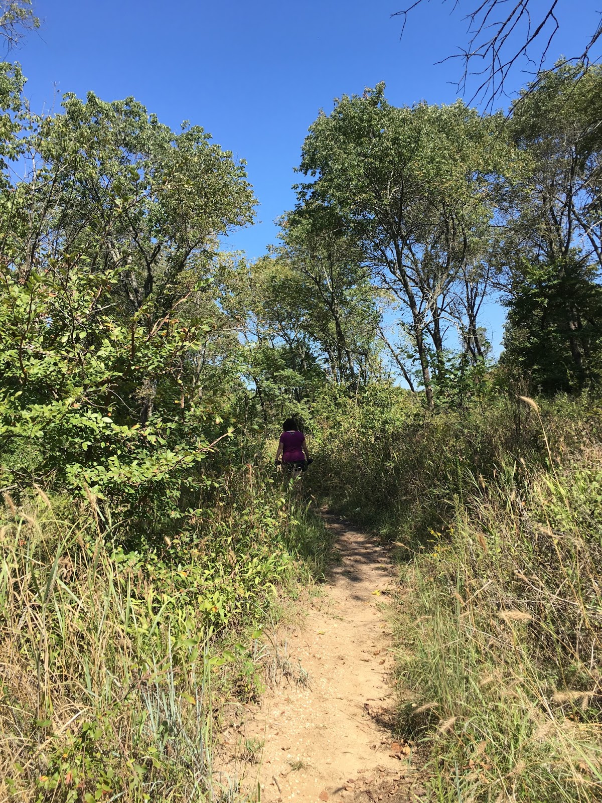
Last year, I ran a 100 miler on the city streets of Tulsa--four 25 mile laps that extended from RunnersWorld 41st/Peoria north through the older midtown neighborhoods, and through downtown, around the OSU campus, onto Rt 66 for a while, around the fairgrounds, south to LafFortune Park, and then back to RunnersWorld. We used Quik Trips for our aid stations, as well as any fast food joint along the way. I really am not a fan of running on pavement, and The early June date turned out to have record 97-degree heat. I finished in over 40 hours and swore I'd never run this race again. But as the race neared, I just HAD to jump in.
Picture by Thomas Gibson
This year the race was moved to late September so you'd THINK it'd be cooler. Wrong! Still, there was a great turnout despite forecasted upper 90s, and then a strong chance of heavy rain. Mitch was my partner in crime last year, and we were the last two in. This year, I actually trained a little and wanted to finish in 30 hours.

Picture by Clint Green
We started at 7:00 am, and I settled into a steady pace. 


Picture by Clint Green
I wanted to knock out 25 miles in 5-6 hours, which seemed doable. I basically ran alone for the first two laps. My strategy was to get in and out of Quik Trips quickly and skip one every once in a while. At times, when the QTs were busy, you could burn 5 extra minutes, and these small bits of tie add up.


Picture by Thomas Gibson
We ran through the Center of the Universe on each loop, and I did the echo thing each time.


Picture by Susan Melon Westmoreland
Near the fairgrounds, a car whizzed by and pulled over behind some construction cones and got out of the car. It was Melon, who just finished eating breakfast with her hubby, and they saw a floppy footed guy running and knew it was me. Melon crewed for me during the 3rd and 4th loops. 


Picture by Thomas Gibson


I borrowed heavily for pictures for this post--trying to shave off a few minutes anyway I could. 


Picture by Clint Green

I finished my 1st loop in 6:36--a little slower thanI wanted, but the temps were rising.


Loop two featured clouds, full-on sunshine, and an occasional good breeze. I took a picture last year of this bank thermometer reading 97. I was not so happy with 100.


Picture by Thomas Gibson

Here I am heading north around LaFortune Park. This is about mile 21in the loop. I usually ran this section well. I finished Loop two in 8:25, despite the heat.

Loop three I had a pacer. My buddy Clint, who is no fan of pavement either, agreed to pace me for one 25 mile loop. I had finished loop two on a high note and had high hopes for a steady run during the night/early morning hours. Things went well for most of the first 10 miles. 

About 2:15 am, we had just crossed under the Broken Arrow Expressway when we heard the sound of squalling tires, and then a crash. We looked toward the direction of the violent sounding car wreck and saw a car flipping over. I called 911 and ran about a block up a residential street to find this car butted up to a huge tree.
Picture by Susan Melon Westmoreland

The driver had stumbled out and surveyed the damage, and then tried in vain to get the car in gear so they could drive away before the cops arrived.  His female companion crawled out and lay down on the ground. Clint went to her aid and noticed her bleeding from her face and neck. From the looks of the crushed windshield, she had probably hit her head prey hard and possibly even jammed her neck.

It took the cops a good 15 minutes to get there, and the ambulance about 30 minutes. I had walked down towards Harvard to flag down a patrol car that was looking for the wreck, and when I came back, a Chinese man was standing out in the yard. He didn't say much, and I thought he must have lived in the house whose  yard we were in. It turned out he was passed out in the backseat of the car. Susan later noticed the back glass f the car had blown out and was partially buried in the yard. This car might have flipped end over end.

Picture by Susan Melon Westmoreland

I was a little shy about taking pictures of the car while the cops were investigating, but Melon had no problem playing paparazzi. It was suggested since I had spent so much time here, that I should go on and let my crew and pacer catch up with me. Clint ran to catch me, and Melon stayed and watched the girl with the hurt neck and the Chinese guy, who turned out to have wat looked like internal injuries) get carted off to the hospital, and the guy who was driving the car flunk a sobriety test and got a free ride to jail. I burned 45 minutes at least, but t was the right thing to do. I'm not sure how well the injured would have fared if we had not heard the wreck.

I really fought sleep issues fro about 4:30-7:00 am. My pace really sucked, and my 3rd loop took 9:44.

Picture by Misty Rowland

Finally, after the sun came up, and it was clear it was not gonna be a 95-100 degree day, I seemed to speed up just a little.

Picture by Laurie Biby

Clint finished my 3rd loop with me and decided to go for another loop. He got credit for running one 25 mile loop, and the medal that goes with it, but prior to this race, 16 miles had been his longest paved race. SO the idea of getting 50 miles in would have been monumental. Here we are on Peoria at Centennial Park, We had around 17 more miles to go, and it was warming up again--although not as hot as it was the day before.

Picture by Laurie Biby
We picked up Laurie Biby somewhere between mile 5-6 on the loop. Laurie matched my pace and was chatty enough to keep me alert and moving.

Picture by Laurie Biby
I had a stretch on 11th Street where I felt disoriented, and Melon started pouring coffee down me. That, plus a ham sandwich and Laurie's chatter perked me up. I started counting the miles we had to go and figuring what pace we needed to maintain to get to the finish line in under 34 hours. I finally decided that if we could average 20-minute miles, we could finish in right at 34 hours, which was the official cut off.

Somewhere on Harvard, Clint started having some aches and pains and caught a ride back. It had started to rain which felt heavenly. We kept gaining a minute or two on our time deficit. At mile 19, another friend Justin Frankin joined me, and I tried to pick it up a little more. I started running on a downhill section, and everything felt great, we ran the first half mile in a little over 4 minutes, and consistently clocked 13-15 minute miles for the rest of the way in. I'm not sure why this worked out the way it did. Sometimes in a race, you find things you didn't know you had.

Picture by Misty Rowland
I was inspired by Justin since he is one who rarely does not win a race he enters. I took maybe 3 or 4 short walk breaks and motored the rest of the way.

Picture by Misty Rowland

Quite proud of my time--some 7 hours faster than last years finish. It's always amazing how the ultra elites hang around to see the last finishers come through. I felt honored to have them waiting and cheering me in.

8:33 for Lap 4. My accepted finish time of 34 hours turned out to be 33:19. Without the car wreck, I might have got close to 32 hours. I would not have finished without the help of Justin, Laurie, Clint, and Melon.


Picture by Thomas Gibson
This lady is Thomas's wife, and although I did not know who she was, she gave me bacon a couple of times during the run. That was a very good thing.


RunnersWorld does a great job with this race. Kathy Hoover works hard with it. (She is also running 4 100s in 4 consecutive weekends--this one, Arkansas Traveller, Heartland, and Pumpkin Holler!!) Derk and Barbara Pinkerton are also instrumental in the smooth operation of this ultra. Roman Broyles spearheads a lot of the RD duties and may be asked by another  RD for hs help and input! It takes a good crew to put on a good race.


I posted this on Facebook. I'm proud of this buckle. A funny thing--a buddy asked, "When is he gonna exhale?" BWAHAHAHAHA!!!

Tuesday, September 20, 2016

Chickasaw WMA / Travertine Creek

Dana and hit the road Monday evening and visited grand kids in Ada. Tuesday, we made an impromptu trip to the Chickasaw WMA and to Travertine Creek, where there are a lot of campgrounds alongside a clear tumbling stream in a heavily wooded area. 
Notice the dotted lines on the right side of the map. These were the trails. Most were flat but a couple of the loops took us to the top of a ridge that would have overlooked the valley below but we could not see the forest for the trees. 

These were "nature trails," mostly to give the Sr citizens who are getting away from it all camping in their luxurious motor homes, and young  families with 4-5 kids and a tent who are also getting away from it all.
These weird trail running types with their mini-backpacks with blue tubes running our of the top were met with odd looks and shaking heads. But Dana and I were enjoying a beautiful morning despite the 80 degrees and 80 humidity. And no breeze.


I was elated to get to a hill!! Nothing looks worse on Strava than a trail run that's FLAT.

I really liked Travertine Creek. It was remarkably clear, and spring fed. These man made bridges gave access to both sides of the creek,and made man made waterfalls--dozens of them.

Another man made waterfall--and I am sure someone will let me know that some of these are natural occurrences. Thank you in advance.

You gotta be careful in the wilderness. You never know what is lurking around the curve in the trail.

Wet feet about to happen. I didn't care.


We found several natural springs, and a couple water basins where I guess group foot soaking were practiced. I took a picture of one such pool, but the pic did not turn out and the only other one I had caught a group on a nature tour. This bridge was cool. Reminds me or the arched bridge at Osage Hills.

We finished up with 3 miles here. There were more nicely (overly) groomed trailz here, but they seemed like more of the same and I had my chops set on trailz over on the WMA. From Veteran's Lake (see map above) I planned on doing the small triangular loop to the lower left of the lake.


We walked 3/10 of a mile down a gravel road to the trail head (yay a HILL) and got onto some rocky mostly un-maintained trails that featured a southbound mile long climb. 


It looks dark here, but it's because the pic was taken mostly into the sun. It was getting hot but every now and then a cloud would earn it's keep by covering up the big fireball. And being out in the open, we had the benefits of what little breeze there was.

The map above was not really accurate, but it did tell me I needed to take all right turns once on the loop. I was almost worrying that our turn might have been an overgrown trail that we couldn't see, so I told myself if we didn't see it after 1.5 miles, I'd turn back. I had my new Salamon S-Lab ADV Skin3 5 Set Pack, with the bladder and the soft bottles filled, and Dana had two 22 ounce Camelback bottles, so we could go most of the day, but we were both set on 6 miles,


Finally, we came to or intersection, about where I thought it would be. This trail headed west and connected to a trail bringing us back north to our Jeep. We got into some wooded areas--giving up the breeze, but gaining some shade.


The trail heading north was mostly downhill, and Dana stole my zombie-shuffle, and we actually picked up our pace until the final climb back up the dirt road. I finished with an even three miles with a short out and back to make the distance. I'm anal like that.

I am no fan of chiggers, and  given that we had ran through potential chigger habitat, and given that there was ice cold spring fed steams a couple of miles away, we headed there for some foot and leg soaking.

This is Little Niagara Falls on Travertine Creek. Looks to be a perfect swimming hole, but I'm not sure swimming is allowed. But OMG!! This was a heavenly foot washing. I scrubbed my calves and behind my knees. I baptized my shoes and socks too. If I had any chiggers, I drowned all those bastards.


And this was the best part of our run!!

Thursday, September 15, 2016

Hills, tall grass, and chiggers

A couple days ago I had a couple hours to kill and needed a good mid-week run with hills, so instead of Turkey, I went to the Wilds of Chandler Park. This wilderness is easily twice the size of Turkey Mountain and has miles and miles of trailz. Some are single track, most are TV trailz, but you rarely see a motorized vehicle there. 

They have a powerline that runs east and west for about 2.5 miles--over twice as long as the powerline at Turkey, and longer steeper hills to boot.

Expect lots or rocks, roots, tree stubs, and if it's wet, figure on 10 pound shoe weights. This clay makes nice chunky pancakes on the bottom of your trail shoes, and where's a good mud scraping rock when you need it??


I ran up one hill, down another and up the next before the sun beat down on me enough to make the shaded trailz more appealing. 


Some of the way was a little overgrown, and lucky me--I had not brought bug spray. I usually spray Repel Permethrin on my shoes and socks and Deep Woods Off (40% DEET) on my legs from the knees down. That usually works fairly well. But without, my legs were begging these bloodsuckers to come and feast.


This is a view to the east where I had ran. Yes, I did run/chug up most of the hills.


Once into the woods, I enjoyed clear tall-grass-free running, and even stopped to check out the latest striped and burnt stolen car. Not much to salvage from this one. I was here a few years ago aand counted 12 stolen/abandoned cars.


The Wild's version of he Spider--a place where several trails dump out into an open area. Which way to go from here? I headed to the bluffs.


Above Avery Drive there are miles of huge towering bluffs perfect for climbing, rappelling, boulder hopping, sitting around a fire ring drinking or partaking of various recreational drugs. There are some kinda-sorta caves, and other caves that only a FEW people know about.


I hit the Hallways--a section that I named due to several passages between mammoth rocks. It did not look like there had been much traffic through here this summer. I started to think about all the loose leaves and brush, and chiggers that can go right through your shoes and socks, so I headed back toward my car.

I wanted to go a different way so as to make a big loop. It looks better on my Strava app. The plan was to run/shuffle/butt slide down the Gauntlet and see the scary brick house that looks like a home for insane clown/zombies, and then head up the 230' mountain bike trail. About half way up the trail, the natural tall grass (effin weeds) completely overgrew the trail, bu I had no choice but to plow through. From there, I headed toward the Chandler Park ball fields, and then headed south to pick up some trails that meandered to the south east along some creek bottoms and out by a pond. It used to be a really good route--not much in the way of hills, and real runnable. But once I got through the maze of rocks, the trail just vanished--like it was never there. I saw another remnant of a trail that headed due east and downward--not one I have ran before--but I followed it down a 1/4 mile to a dead end and more weeds aka launching pads for ticks and such. I picked off a dozen or so seed ticks along the way.

So rather than retracing my steps back to the slightly more established trailz, I started bush whacking the direction I remembered the trail being. Bad idea. My keen sense of direction did get me finally to an intersecting trail that took me on to where I needed to go, but it took all the fun out of an otherwise fun outing. I finished with 6 miles right on the button and 758' of ascent. I like that.

Two tick bites were not that bad, but that night the chiggers started itching. And a day later, it seemed lie even more popped up. Last night, Dana and I ate outside at Qdoba, and mosquitos started feeding on my ankles--right n top od a rash of chigger bites. I ended up in an itching frenzy!! I drove home, then rushed in the house, stripped off my soes and socks and did some serious fingernail-scraping scratching--gotta make it belld. Then I rubbed BioFreeze all over the bites and took three benedryl. That helped. Still--this wasn't the worse chiggers I've ever had. But it's in the top five!!!

Sunday, September 11, 2016

TZ and TaturCakes' trail dogs

A little over a year ago, these two puppies joined our family. Roxie was sort of a rescue dog. She was born on a farm and her canine family were outside-only dogs. We got her when she was 7-8 weeks old (owners were not sure) and the two girls they had left were both timid and skeptical of this so-called adoption process. Roxie had longer hair than her sister, and we just fell in love with her. We paid what the owners wanted, and they advised us that she "might" have a few ticks. On the way home from Stroud, Roxie sat in Dana's lap and Dana picked off several ticks and flicked them out the window. (Cruelty to ticks?? YES!!!) When we got her home, we spent hours and hours picking of what was into the hundreds of ticks. Our friend Susan came over to the then new puppy. She and Dana just kept pulling the blood-suckers off. In the folds of the pads on her feet, each paw had several dozen ticks--many fully engorged. The next day, we took her to our vet, and he determined that there was no danger to her health despite the tick coverage, and gave her a flea/tick dose that he assured us would take care of any stragglers. It did--we found dead ticks on the floor for the next couple of days. Roxie is supposed to be half Pyrenees/half chocolate lab--but I think she may be half Burmese, not Pyrenees. Roxie took over the house in no time, and has grown into a beautiful intelligent young lady (although she definitely has a bratty side.) 

But we just kept thinking she would be lonely by herself, and we really wanted a chocolate lab male, and we found the one we wanted in Hugo Oklahoma. Zeke just crawled right up in our lap when we saw him for the first time, and he still thinks he's a lap dog some 95 pounds later. He was the easiest dog to potty-train ever, and like a lab, LOVES to play fetch. These two dogs are inseparable. Sometimes squabble like they hate each other, but whine when the other is not nearby.

Zeke and Roxie at around 2 months old
It was a given that these two should be trail dogs, and when they were around two months of age, we took them on their first trail exploration. They were full of curiosity, and Turkey Mountain has an unending buffet of smells. Their excitement is not so much for the miles, but for the smells, and the critters that make these smells. The sight of a rabbit, armadillo, or deer sends them into a frenzy. Now that they are older and heavier, having them on a tandem leash is a real challenge when a bunny crosses their path!


A year later at around 14 months old. Roxie is 62 lbs, and Zeke tips the scales at 100 lbs
So we compromise. For the first mile, I give them all the sniffing time they want, then we focus on being good trail dogs. This works out about right. When they fall into trail boss mode, they look like champs. Side by side--tails flying like a flag--I'm so proud of them. Both dogs step off the trail to pee and poop. I'm not sure how they learned that this is proper, but they have never dropped a load where a trail-runner would step on it! (That certainly is NOT the case with a lot of other dog visitors.)

Right now, they are three-mile dogs. I have taken them a bit longer a couple of times, and they really seem wiped out (and sleep like logs when they get home.) They both get excited when they see me get out the leash and harnesses, and in fact, we are going to Turkey Mountain for another run in a few minutes!

Monday, September 5, 2016

McGee Creek. Never Stop Exploring

After running Sizzlin' Sasquatch Sunday, I decided to head over to McGee Creek to check out some trailz I had read about. I plugged McGee Creek into Google Maps, and away I went. Somewhere between Coalgate and Atoka, my cell phone ran out of any resemblance of a signal, but the Google map app seemed to work albeit slow. So on I went.

It sent me to the location marked by the green arrow, which was a campground. Upon turning into the camp ground, I was an encouraging sign: Potapo Hill Trail. I parked, set my Suunto, and off I went.

Yeah, the trail sign said it was only 1.4 miles. I thought it might be one way (I didn't read the "Loop" on the sign.)


This is everything I like in a trail. A well defined trail, pine needle covered, tall pine trees, wind whirring through the tree tops, bright blue skies.


Of course I had to take an upward tree shot. 


And true to the sign, the trail was a loop, coming back within about 20 yards of the original trail head.


Just across the access road, I found this pond with a trail going around it. BONUS!


A beautiful side trip, but the trail went less than a quarter mile. So it was back to the drawing board. I could not get on the internet with no signal. My iPhone kept saying "sim card not installed." To my knowledge, my phone does not have a sim card. But the google map app was working well enough to give me an image of a gravel road going for miles through the heart of the WMA, but it was around 20+ miles away. So of course I had to go check it out.

The outlined road was a fantastic gravel road, semi-scenic, and I just knew it would take me to the awesome bunch of trails I'd read about.

While this 10 mile stretch of road would make a good run with lots of hills, it was not quite what I hoped to find. 


About half way out, I saw a pull-off area with what looked like a Kodak moment. I was on top of a long ridge, and this was one of only a few places where you could see over the trees to see you were actually on the edge of a long high hill.


The view was grand, but there was no possibility of getting into the dense woods. This is a very vast, secluded, untrafficked plot of land--used for hunting of course. 


There were a few other pull-off areas designated for parking, but it did not look like these had been used for months, maybe years. Occasionally I'd see an overgrown road marked to prohibit motorized traffic.


One such road near this picture had a hint of a road heading downward toward the lake. I parked and decided to give it a good look.


Hoping this would turn into a few miles of trail running, I followed this road steeply downward for .4 of a mile.


The view of the lake was worth it, but at the water the trail ended.


I'm not sure what the purpose of this road was other than upper lake access. 


Not many fishermen would hike down a 174' decent to fish, only to have to climb back out. But I loved it. Just wish it was longer. (TWSS!!)

Well once I got home, I found the map that showed where these miles and miles of trails were located. I was maybe a couple of miles away as the crow flies, but a good 20-30 way by car. The little green arrow marks the trail head, and the map below shows all the trail offerings.

Another road trip is definitely in order!!