Tuesday, November 2, 2010
A New Favorite: Pumpkin Holler
I have always been fascinated with maps. When I started running on trails a few years ago, that fascination was helpful in finding new places to run. A good map or state atlas that shows elevation lines and names certain mountains and hiking trails is a great read for me. While cruising through the pages of my Oklahoma atlas, I found an area along the Illinois River that had a rural road running alongside it. This series of red lines indicated a long winding loop through valleys and over mountains miles away from the buzz of the city.
East of Tahlequah and north on HW 10, Eagle Bluff Resort is at gravel road that has an old steel bridge that crosses the Illinois. It is the only bridge between HWs 51 and 412. From there, the next left turn begins the loop below. There are a few (but just a few) important turns to make to complete this loop. In the first mile, we were treated to a riverside drive.
 This road is a sweet runnable surface. Smooth as the chat on a running track. The county or state--whoever does the road maintenance does a superb job.
 There are a few ups and downs, but not excruciating climbs at all.
 The leaves are changing but are not as colorful as they might have been since the last two months have been so dry. This section was about a mile long, and was a slight downhill grade--perfect for a quicker tempo-ed run.
 Most of this loop is shaded, but there are a few more open areas.


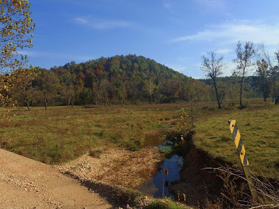
 Even as dry as it has been, there were a few water crossings.
 There is a short three mile section of paved road on this loop. It's a county road, and is mostly downhill. The scenery does not drop off on this paved stretch.
 Then there is the steepest climb on the course. It's about a half mile long, and is still runnable.
 The payoff is an equally long downhill. The most colorful leaves were during this stretch at around mile 22.
 On the entire loop, and we drove it twice, we only saw 5 vehicles moving--it's not a highly traveled road. We did have an audience at one point though.
 Finally, our loop was done. This is shot is taken from the steel bridge we crossed to begin our adventure.
I'm calling this the "Pumpkin Hollow course". One of the county roads between mile 10 and 20 is called Pumpkin Hollow--love it! I plan to go back in a few weeks to give it another go--this time on foot. Anyone wanna go?
++++++++++++++++++++++++++++++++++++++++++++++++++
This post below is a subsequent trip Brian, Stormy, and I made to measure the course and determine where the aid satations will be. This trip was made on April 9th, 2011.
After the race, Brian joined Stormy and I and we headed to Pumpkin Holler. The plan was to drive the course and carefully Garmin the distance and elevation. This map is posted at the Nickel Nature Preserve, and the red loop is almost exactly the Pumpkin Holler course. The red line is the road we use. The race starts at the Eagle Bluff campground, and we'll run the loop clockwise. At the top of the loop after veering away from the river, we'll take the left road at the Y and do a 1.7 mile out-and-back which makes the loop 31.1 miles. Two loops make a 100K. The 100 milers get their extra mileage out of the way at the start. From the start, they turn RIGHT instead of left when they reach the loop. Then they make a left on the red road that cuts right through the center of the loop. Their turn-around is near the Tulley Hollow intersection, about half way through the preserve. This route includes a pretty good climb--maybe the steepest on the whole course--but you get it out of the way early while every one's legs are still fresh. Again, only the 100 milers do this out-and-back. After that, they do three of the big loops and they're done. Easy, right?
 This old church is right at the beginning of the 50K loop.
 This is around mile 5. At several places on the loop, you get to run right along the scenic Illinois River.
 A look back the other direction.
 This is the intersection where the first aid station is. This is also where the 1.7 mile out-and-back is. You had best not miss this turn. We are thinking of having a timing mat at the turn-around.
 Another aid station locale. Brian is busy with his super duper high powered camera. I would love to have one like it, but might get a hernia lifting it.
 Stormy did all the driving, was right on top of the Garminning and note taking, and the next day gave us a spread sheet with every landmark imaginable on the course including every cattle guard, every water crossing, every hill summit, intersection, switchback and hair-pin turn.
 The trees in the area are beginning to bud out. Come race day, the leaves should be turning. Hopefully, we'll have a technicolor show.
 I liked this pic. It seems fitting that a TATUR window sticker should have some dirt to go with it.
 Finish the Pumpkin Holler Hunnerd, and you can put this sticker on your bumper.
After driving the course, Stormy and I checked out some actual trails inside the nature preserve for a future
East of Tahlequah and north on HW 10, Eagle Bluff Resort is at gravel road that has an old steel bridge that crosses the Illinois.
 It is the only bridge between HWs 51 and 412. From there, the next left turn begins the loop below. There are a few (but just a few) important turns to make to complete this loop. In the first mile, we were treated to a riverside drive.
 This road is a sweet runnable surface. Smooth as the chat on a running track. The county or state--whoever does the road maintenance does a superb job.
 There are a few ups and downs, but not excruciating climbs at all.
 The leaves are changing but are not as colorful as they might have been since the last two months have been so dry. This section was about a mile long, and was a slight downhill grade--perfect for a quicker tempo-ed run.
 Most of this loop is shaded, but there are a few more open areas.


 Even as dry as it has been, there were a few water crossings.

 There is a short three mile section of paved road on this loop. It's a county road, and is mostly downhill. The scenery does not drop off on this paved stretch.
 Then there is the steepest climb on the course. It's about a half mile long, and is still runnable.
 The payoff is an equally long downhill. The most colorful leaves were during this stretch at around mile 22.
 On the entire loop, and we drove it twice, we only saw 5 vehicles moving--it's not a highly traveled road. We did have an audience at one point though.
 Finally, our loop was done. This is shot is taken from the steel bridge we crossed to begin our adventure.
I'm calling this the "Pumpkin Hollow course". One of the county roads between mile 10 and 20 is called Pumpkin Hollow--love it! I plan to go back in a few weeks to give it another go--this time on foot. Anyone wanna go?
++++++++++++++++++++++++++++++++++++++++++++++++++
This post below is a subsequent trip Brian, Stormy, and I made to measure the course and determine where the aid satations will be. This trip was made on April 9th, 2011.
After the race, Brian joined Stormy and I and we headed to Pumpkin Holler. The plan was to drive the course and carefully Garmin the distance and elevation.
 This map is posted at the Nickel Nature Preserve, and the red loop is almost exactly the Pumpkin Holler course. The red line is the road we use. The race starts at the Eagle Bluff campground, and we'll run the loop clockwise. At the top of the loop after veering away from the river, we'll take the left road at the Y and do a 1.7 mile out-and-back which makes the loop 31.1 miles. Two loops make a 100K. The 100 milers get their extra mileage out of the way at the start. From the start, they turn RIGHT instead of left when they reach the loop. Then they make a left on the red road that cuts right through the center of the loop. Their turn-around is near the Tulley Hollow intersection, about half way through the preserve. This route includes a pretty good climb--maybe the steepest on the whole course--but you get it out of the way early while every one's legs are still fresh. Again, only the 100 milers do this out-and-back. After that, they do three of the big loops and they're done. Easy, right?
 This old church is right at the beginning of the 50K loop.
 This is around mile 5. At several places on the loop, you get to run right along the scenic Illinois River.
 A look back the other direction.
 This is the intersection where the first aid station is. This is also where the 1.7 mile out-and-back is. You had best not miss this turn. We are thinking of having a timing mat at the turn-around.
 Another aid station locale. Brian is busy with his super duper high powered camera. I would love to have one like it, but might get a hernia lifting it.
 Stormy did all the driving, was right on top of the Garminning and note taking, and the next day gave us a spread sheet with every landmark imaginable on the course including every cattle guard, every water crossing, every hill summit, intersection, switchback and hair-pin turn.
 The trees in the area are beginning to bud out. Come race day, the leaves should be turning. Hopefully, we'll have a technicolor show.
 I liked this pic. It seems fitting that a TATUR window sticker should have some dirt to go with it.
 Finish the Pumpkin Holler Hunnerd, and you can put this sticker on your bumper.
After driving the course, Stormy and I checked out some actual trails inside the nature preserve for a future
No comments:
Post a Comment