
Susan Melon Westmoreland designed the shirts and local screen printer Caveman Screen Printing produced what has become my current favorite tee.

This map is a fairly accurate detail of the trailz and the course we took. We started near the swimming pool, went by the waterfalls, over to the Creek Loop and bluffs, then north on the Tower/Lake trail. We added an out and back across the dam of Lookout Lake, and then headed to the Mountain Bike Trailz. The original plan was to take the Red Trail clockwise,and then take the Blue Trail counter clockwise, and finally returning to the finish for one 13.1 mile loop.

I saw Friday that doing that had three problems. One: the course was almost a mile short. Two: It would require hauling an aid station or water drop a good half mile up hill on a trail that was technical in places. Three: The Blue trail had waist high grass and places and needed almost two miles of serious weed eating.
Brain and I spent most of Friday whacking weeds on the Red Trail, and late Friday afternoon, I saw first hand how bad the Blue Trail was. The solution was to run the Red Trail and we'd place an aid station near the end on an alternate trail head, and then run the Red Trail in reverse. We could get a table and tent with all the aid station stuff easily to this spot, it added the right amount of mileage to our course, and it eliminated the need to whack two miles of tall grass. Plus, it added a water crossing!
The course was marked with signs with arrows. I thought it was bombproof. But somehow a sign got turned pointing people down the blue trail. Adding confirmation that this "wrong way" was the right way--was two signs 100 yards up the blue trail that were part of the pre-marking. They were out of sight from the proper route, but once the wrong turn was made, it seemed to confirm that the Blue was the correct way. YIKES!
So now, most of the half and full marathoners went 5.5 miles with no aid, came up short on their mileage, and waded through a couple miles of weeds. There is no way after the fact to fix this. I placed every sign--I know exactly where every sign was placed-- and I am sick that the course markings were tampered with. So the way it will stand--the results will stay as they are. Anyone who truly feels they were shortchanged on mileage, or their placement in the race standings can contact me and I will grant them entry to one of our remaining trail races this year.
Now on to better things.

The half and full started at 7:30, and a rowdy crows took off thundering down a short strip of asphalt before spilling onto some soft dirt en-route to Sand Creek Falls.
The 5K started at 8:00 and did the same loop--skipping the Creek Loop Trail, the northern half of the Tower/Lake Trail, and all of the mountain bike trailz.
 |
| Picture by Michelle Bates |
 |
| Picture by Michelle Bates |

Next up, the Sand Creek Bluffs, and then the Creek Trail.
 |
| Picture by Michelle Bates |

The Creel Trail is a mile long loop that is TRULY relatively flat. No rocks, no roots. Horse flies--might have been a few.

 |
| Picture by Arena Mueller |

You had to look for it, but this arch \bridge which was right before you crossed the road before the Devil's Intersection aid station.

Including an out and back across the Lookout Lake dam helped get the mileage to where we needed it for a two-loop marathon. I heard no complaints on this. I'd love to see trailz cut around the perimeter of the lake.

And a word to the aid station workers--Shorty and Luke Jennings along with Mishelle Hancock manned Devil's Intersection, working 8 solid hours Runners hit this aid station three times, and they had the responsibility of making sure everyone went the right way.

This is an old storehouse (looks more like a jail) by the mountain bike trail head. This was a welcome sight for those nearing the end of their loop.
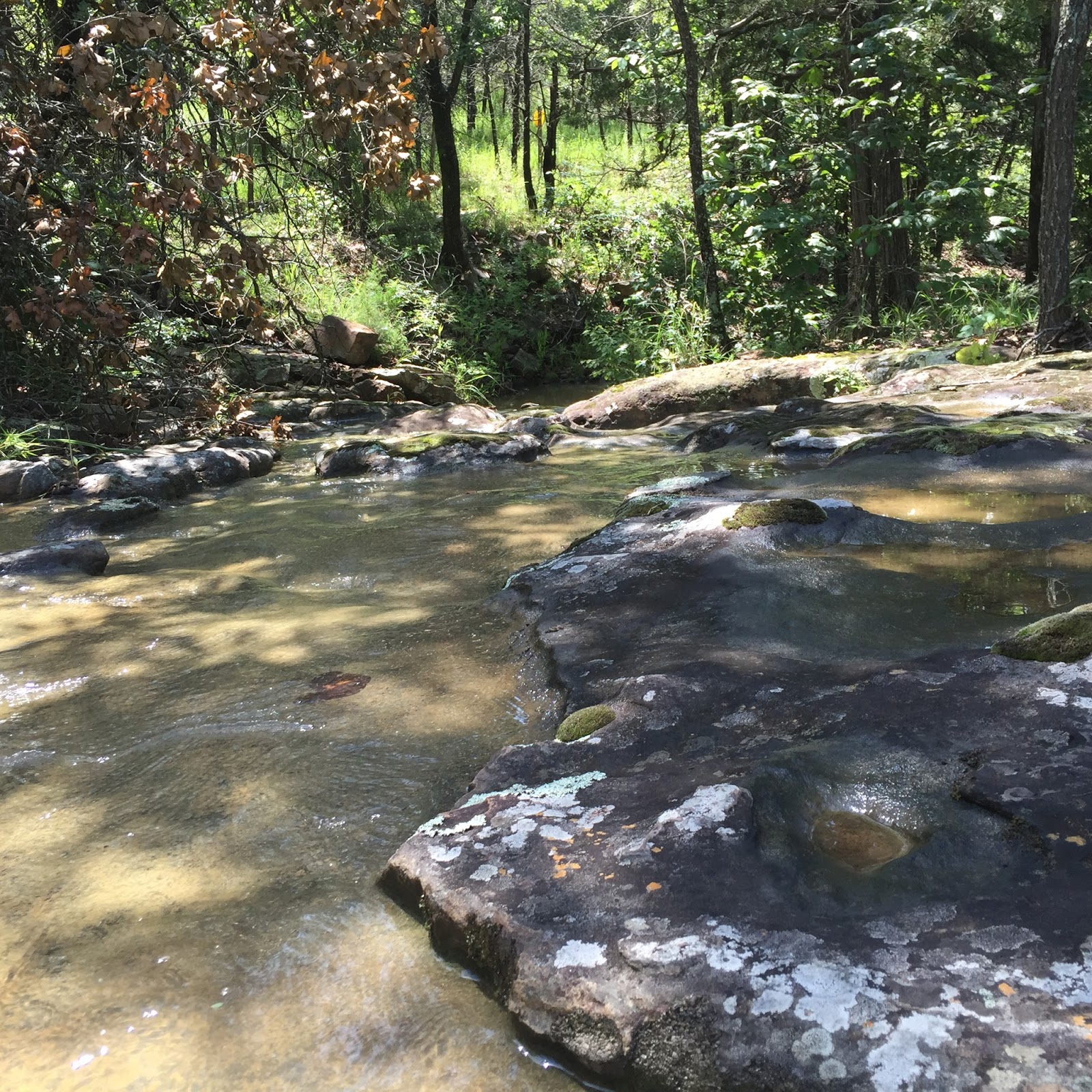
The Red Trail had several water crossings like this. It started and finished with creek crossings that were shoe fillers. These rocky crossings were passable, but were also a great place to wet your face, hat, t-shirt. feet, or to just sit down in.

This crossing at the end of the Red Trail (a lot of people missed this one) had impressive bluffs downstream, and a small waterfall upstream.
 |
| Picture by Jessi Wiley |
Many thanks to all who helped. Mike Rives and Travis Jennings helped me assassinate weeds Saturday before the race. Travis killed his marathon, and then stayed to help load stuff up after the race. Brian Hoover, besides timing the race, helped me chop weeds Friday, and made the finishers medals. Susan Melon Westmoreland handled the shirt production. Krystal Brown and Dalton Messenger manned the first aid station. Melissa Messenger distributed finishers medals after her stellar 5K finish. Michelle Bates jumped in and helped with prerace registration and packet pickup before her 5K. Jason and Sue Ann manned the unmanned aid station after their half finish, and stayed around and helped pack things up after the race. And last, but best, Dana aka TaturCaskes rounded up all the aid station food and supplies the few days before the race, cooked and served food and helped with the start/finish aid station, helped everywhere around the start/finish, then unpacked and cleaned up and put away everything at home after the race while I took a nap.
I reserve the right to add people who helped that I am not remembering right now.

Finally--it has been brought to my attention that this course was ANYTHING but flat. Having a flat course is boring. Hills are good for your heart. Look at the above elevation profile. It LOOKS healthy. It looks like a pulse line, does it not? If it were flat--well flat lining is very bad. Relatively flat is your friend.
Now the course elevation below has a vague resemblance to the one above. However, it IS hilly. You might say it's a Monster of a course. I would not call it flat.

Another gem of a race that only you could put on. Sorry I missed it.
ReplyDelete