It was a gray cold day, the day before Christmas. Dana had to work a 12 and I had a few things to pick up at the store, and a couple of gifts to pick up that had been back-ordered over in the war zone. Then, if all went well, I needed a run, having not ran since Tuesday, and that was a shortie.
I know a lot of shortcuts around town, and was able to slip in the back way to Mathis Brothers Furniture and get back out while seeing hardly a car! This is ~ a half mile from major traffic jambs and road-raged maniacal last minute Christmas shoppers.

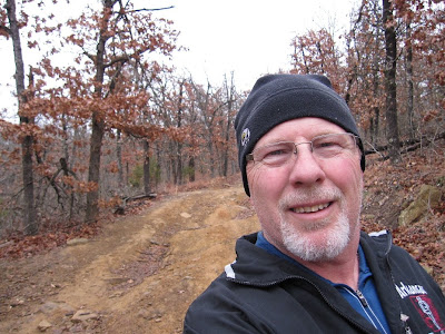
The drabness of the day merited a snapshot. I always carry my Canon now!! This gray asphalt road was quickly behind me, and soon I was in the hills west of Chandler Park!!
 No pavement here. But lots of hills, dirt, rocks, and roots.
 And mud. It had rained just a little last night. The trails did not even look muddy, but the dirt was damp enough to cake up like weights on my shoes. I got a great workout lugging it around!
 One mile in, and I am happy despite the cold and wind.
 My plan was simply to explore. I had my Garmin--not so much for the pace aspect, but the distance and compass capabilities. I had 3 hours to run before total darkness, and wanted to use every minute of it. Roughly, I wanted to go from the NE corner of the area to the SW corner and back--preferably in a big loop. So, I'd turn left, and then right at the next intersection. And repeat.
 One left turn took me right up this ravine. I'd be a little nervous going this way in the summer, as the deep leaves would be great snake habitat.
 Here's natures version of Christmas tree ornaments.
 The next turn took me uphill. There were several short steep climbs on my route today. Burn baby, burn!
On this climb, I stopped to take a picture of a face in the rocks. Possibly a fossil of an alien??
 I kept the left turn/right turn pattern going, and was pretty sure I was nearing the far corner.
 Ok, I have good imagination--do you see the alligatot in this root?
I heard the cars from either 41st Street or HW 97, and checked my mileage and time. Hmmm....I had gone 3.95 miles and had less than an hour to make it back to my car. I'd have to hurry. The sun made a valliant effort to pucture the dense clouds. Would have liked to had some sun, but I like the fact that it tried.
 The trees look a little more daunting as darkness sets in.
 I knew a shortcut. The powerlines that bisect this huge plot of land has a fire road and goes straight as an arrow (well, a crooked arrow maybe) and this trail would have the most light if I took longer than expected. Between where I was and the distant horizon (1.5 miles) was a deep and long valley, with a steep climb up the other side.
 I ran more in the last couple of miles, stopping for only a few pictures. The last climb--it's a doozie.
 Another shortcut--down this wash cut off a tenth or so, and bypassed a low area with lots of sticky clay-like mud.
Muddy conditions usually means there's lots of animal tracks. I actually saw very few, but near the end, this caught my attention. Someone will probably tell me it's a german shepard track, but I was thinking cat track.
 And now, there are a lot of Zombie tracks all over the place!
I know a lot of shortcuts around town, and was able to slip in the back way to Mathis Brothers Furniture and get back out while seeing hardly a car! This is ~ a half mile from major traffic jambs and road-raged maniacal last minute Christmas shoppers.

The drabness of the day merited a snapshot. I always carry my Canon now!! This gray asphalt road was quickly behind me, and soon I was in the hills west of Chandler Park!!
 No pavement here. But lots of hills, dirt, rocks, and roots.
 And mud. It had rained just a little last night. The trails did not even look muddy, but the dirt was damp enough to cake up like weights on my shoes. I got a great workout lugging it around!
 One mile in, and I am happy despite the cold and wind.
 My plan was simply to explore. I had my Garmin--not so much for the pace aspect, but the distance and compass capabilities. I had 3 hours to run before total darkness, and wanted to use every minute of it. Roughly, I wanted to go from the NE corner of the area to the SW corner and back--preferably in a big loop. So, I'd turn left, and then right at the next intersection. And repeat.
 One left turn took me right up this ravine. I'd be a little nervous going this way in the summer, as the deep leaves would be great snake habitat.
 Here's natures version of Christmas tree ornaments.
 The next turn took me uphill. There were several short steep climbs on my route today. Burn baby, burn!
On this climb, I stopped to take a picture of a face in the rocks.
 Possibly a fossil of an alien??
 I kept the left turn/right turn pattern going, and was pretty sure I was nearing the far corner.
 Ok, I have good imagination--do you see the alligatot in this root?
I heard the cars from either 41st Street or HW 97, and checked my mileage and time. Hmmm....I had gone 3.95 miles and had less than an hour to make it back to my car. I'd have to hurry.
 The sun made a valliant effort to pucture the dense clouds. Would have liked to had some sun, but I like the fact that it tried.
 The trees look a little more daunting as darkness sets in.
 I knew a shortcut. The powerlines that bisect this huge plot of land has a fire road and goes straight as an arrow (well, a crooked arrow maybe) and this trail would have the most light if I took longer than expected. Between where I was and the distant horizon (1.5 miles) was a deep and long valley, with a steep climb up the other side.
 I ran more in the last couple of miles, stopping for only a few pictures. The last climb--it's a doozie.
 Another shortcut--down this wash cut off a tenth or so, and bypassed a low area with lots of sticky clay-like mud.
Muddy conditions usually means there's lots of animal tracks. I actually saw very few, but near the end, this caught my attention.
 Someone will probably tell me it's a german shepard track, but I was thinking cat track.
 And now, there are a lot of Zombie tracks all over the place!
No comments:
Post a Comment