I'm staying home. But I will get in back to back long runs over the weekend. I better!
I had an out-of-town stop today and ended up in Claremore. I had an itch to do some geocaching, and found four rather quickly. I also needed to get a run in for my streak, and decided the Centennial Trail by Lake Oologah would be cool.
I thought I could get a nice four miler by doing the trail that ran the perimeter of the peninsula.
But after hopping from side to side on the muddy horse trailz, I turned back around.
So I crossed the lake and tried the Hawthorne Park area where there are 3 miles of rocky trailz. But they have imposed a $3.00 per car fee even if you're just driving in, and they had the road that led to the trail head barricaded. I blew that off, but still took a couple pics from the boat ramp area.
The views from this trail are breath-taking, but my pix were less so. Obviously, I tinkered with this one.
So, I consulted my geocache app to see what kind of caches were nearby, and noticed I was not far from Goose Island. I used to fish a lot at Oologah, but had never been there. I'm really not sure why I never checked it out?
There were no caches hidden here, but I thought it might be a good place to squeeze a run in.
I got there just as the sun was setting, and my trusty headlamp was at home. I snapped a couple of pics and headed out running.
There are a few miles of dirt roads accommodating hunters. Most are straight and boring, but as they near the shores, they wind around and the lakeside views are stunning! I ran through the woods, crashed through some briers, ran a little on the dirt roads, and then about a half mile on the rocky shores of the lake. Hopping and scrambling over rocks was a super workout.
I ran 1.5 miles and it was starting to get a little too dark to glide over the rocks. Wish I had more time. I am definitely going back soon to run the entire perimeter of the island, but I have a feeling that it better not be during hunting season.
I had a sales call in Collinsville at 1:30, and I took some running clothes to change into so I could either geocache, or run trailz at Oologah Lake. There was a geocache somewhere out on the trailz here, but I felt like running.
 As I do whenever possible, I took a picture of the map. I would refer to this a couple of times, but it did not do me much good.
 Notice the peninsula? The trail (the dotted line in the map above) runs the perimeter of this sometimes-island. I have made the trip out, around the loop, and back a few times in years past. It was a treat--back then.
 This chunk of wilderness in the lake has some significant climbs, with over 100 feet of climb in two or three places. There are no houses, campsites, or any civilization there--just some equestrian trailz that work nice for my purposes.
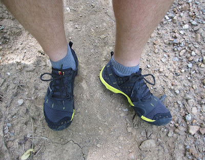 I was wearing my New Balance Minimus shoes--something I thought I'd NEVER do. I felt that to honestly oppose the minimalist movement, I should give them a try. I actually like them! I am much lighter on my feet, and trail running seems even more fun.
 The trailz started out nice and wide, hard packed, and bone dry. The first half mile is at times muddy, and the horse hoofs beat the trail up pretty bad, and then when the clay-like mud dries, it is very rugged. But it only is that way for a short distance.
 I took a spur trail to bypass some of the chewed up horse hoof sections, This trail was a little bit overgrown, but I knew it tied back into the main trail pretty quick.
 There were several tree-falls in the area. Most were a nice hop to bound over, but there were a couple that were hard to get around/through.
 Back on the good trailz. This looks like it might have been a road many years ago. This road has about a quarter mile that is underwater if the lake is up.
 After the lowest point, the trail begins a gradual climb onto the peninsula. I knew to keep an eye out for a left turn that would run the perimeter.
 Here's where it got "interesting". It really looked like this trail gets no use whatsoever. I don't mind a few plants/weeds/briers slapping my legs, but it was far worse than that. I am sure there was a healthy growth of poison ivy, and I'm really gonna be putting my chemically induced PI immunity to the test.
 Beside the overgrowth, the trailz did not seem at all familiar. I have a good sense of direction, and it seemed like the trail snaked back and forth up and down the mountain, and not at all like a big perimeter loop. Did I say SNAKED? No, I did not see any snakes, but I could have easily have stepped on one without even knowing it.
 The conditions of the trailz got progressively worse. Had I missed a turn?? Maybe I had. It did not seem like the trailz I was on were traversing the perimeter of the peninsula. I definitely think there were some trailz that were NOT on the map.
The trail I was looking for, as I remember it from a few years back, eventually got to the west side of the peninsula and ran right along the shore and at times on a series of bluffs.
The conditions of the trailz got progressively worse. Had I missed a turn?? Maybe I had. It did not seem like the trailz I was on were traversing the perimeter of the peninsula. I definitely think there were some trailz that were NOT on the map.
The trail I was looking for, as I remember it from a few years back, eventually got to the west side of the peninsula and ran right along the shore and at times on a series of bluffs.
 This is a pic I dug up off of an old disc from 4 years back or so. The views are well worth the six mile round trip. But this time, I will admit to being lost--on a 103° day with a 22 oz water bottle that was less than half full. Luckily, I stumbled onto a trail that looked familiar, one that headed downhill and west toward the bluffs. But 1/4 mile down this trail, a huge tree had fallen, and the only way around was through a massive amount of briers and poison ivy (not to mention ticks and chiggers.) The best decision was to turn around and head back. At least I was now sure of where I was. I found a bypass trail that took me straight down the wooded hill to the end of the loop that I had not been able to find--a relief, to say the least.
 I knew this was spot was only a mile from where my car was, and I had a few swallows of water to spare.
 The Tick-o-meter tally took a hike upward. I ended up with 10 of these spotted ticks, and about half of them latched on.
 These roving freckles are seed ticks. I found 5-6 of these guys. Not sure if any latched on, but quite a few chiggers made their mark.
I had given thought to suggesting a TOT run here, but that will have to wait--until after a hard freeze (or maybe when hell freezes over.)


