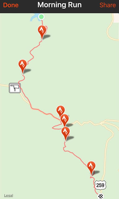
The usual Sunday group of traveling trail runners was small--like just me and Brian. I was looking for 15-16 miles, and Brian was looking for the same with a well-placed decimal. He brought his drone and his Go-Pro and some sort of turkey-neck looking camera holder. He was looking to try out some of his new gadgets and make a MOVIE or two.
I picked Cedar Lake--I've been here a few times, and knew that there were lots of distance options, and I had plotted out several potential routes including the 3-mile trail around this scenic mountain lake in SW Oklahoma. Since I am signed up for one of the toughest 100s in the US, I NEED HILLS, elevation gain--even more than I need distance. Climbing 100 feet blows the desired running pace out the window, but it gets to where those moderate grinders start to seem like gradual downhills, and I am banking on that switch in perception being my key to finding the finish line at my 100 this October.
Since it was just me running, I skipped the flattish shoreline trail and instead jumped right into what turned out to be a
9-mile climb to the top of the Talimena Drive via the Horsethief Springs Trail and an old gravel forest service road.
Around every curve in the trail, the road just kept going up. My own punishment!! It seemed to me that this might never end. Focusing on a steady shuffle and found my overall pace in the lower 18s. While this probably seems super slow, 18 m/ms will get me a belt buckle in October.
This is a good route--I will definitely come back for more of this insanity. Brian was meeting me at the top, but when I got there he was missing. At the top, I found that apparently, 2400 feet hills make for good cell phone signals. With both of our phones GPS's spitting our locations, we met up right away.
Brian was just down the road a couple of miles at the Winding Stair Campground and he sped right back to where I was. He told me about the Emerald Vista, and that there was a downhill and then a hellacious uphill between the Vista and where we were. He offered to give me a lift and I declined. I needed the elevation.
The Talimena Scenic Highway is famous for the Fall Foliage, but today it was all green. My two mile run on pavement here was so amazing--almost cool weather, a nice steady breeze to chill my sweaty shirt, the smell of pine trees coupled with the gentle whir of the wind sifting through the tall branches, just me and infinite expanses of blue sky approving of my quiet shuffle on a Sunday afternoon.
I found the campground and graciously gobbled up the extra bonus mileage running down to the Emerald Vista where Brian was chilling out at a shaded picnic table with an old gray-bearded man who had for years enjoyed the same pleasures as I--but on his Harley Davidson. It's not always running that puts you in that zen state. We were kindred spirits, and I was glad we had met him.
My plan was to run back to Cedar Lake on a parallel trail--but I was a little unsure of how to find where I needed to turn. (I've figured out now where I would have needed to go.) Being the spontaneous glutton for punishment that I am, I realized I was not far at all from the turnaround aid station we see in the Ouachita Switchbacks. In about the same distance I would run back to Cedar Lake, I could hop onto the Ouachita Trail at Winding Stair Campground, and turn to HWY 259 where the first Switchbacks aid station is. I would gain two more good climbs, and also still enjoy a 3-mile gradual downhill. This is how bad ideas always come into existence on my running trips!
I forgot how technical this trail was. I had run 9 miles on pavement and good gravel roads. Now I could not pick up my feet enough and kept kicking rocks. I was slower running downhill on the technical stuff than I was coming uphill on the forest service roads. I never fell although I did slightly bruise up the bottoms of my feet. But the worst thing on this 6 miles of single track was the spider webs. They were old webs--strong, thick webs. The wind drag was significant. I found a good spider web stick, and sure enough--every time I'd swat one down, I'd get plastered in the face with another. It seemed like no one had used this trail since the Switchbacks race.
Both times I have run this before, it was in the dead of winter, and during leaf-off, the trail looks way different. I was sure I was on the right trail--there are not many off-shoots on the OT. I actually stopped twice and looked at Google Maps, which has the OT outlined, to see if I was still on the correct route--and I was.
Brian was getting a little worried about me, but I came in on pace--just the estimated mileage was wrong. I ran almost 7 miles on what I thought should have been 5.5.
15.1miles point to point. I'd run this route again!!
This was one healthy climb.
Hopefully next week we'll have a few additional runners.


