Yesterday, I drove to the Pumpkin Holler Hunnerd course to do a little mapping--particularly to find good driving routes for the crew to get to the crew-access stations. The plan was to find a way for the crew vehicles to get there without driving on the course. Google maps is a great tool, but sometimes it shows roads that are really not there. Farmer Brown drives his John Deere across a field, and that swatch of beat down grass shows up on Google maps as a road. That can get you in trouble!!

I drove the course, and found a perfect way in to the Hard-Up Ahead station, that is all paved!! YAY!! I then followed the course toward the Nickel Preserve headquarters and I hoped to meet with those folks to tell them about our event. Upon getting there, the doors to the building were unlocked, and I let myself in. "Anybody here?" Hellooooo?" I guess they aren't afraid of anyone coming in and carting the place away. Maybe I'll get to see them next time.

With a little luck, and a little rain, we may still have great leaves come October. It's been dry, but I am thinking maybe this area has got as few more drops of precip than we have in Tulsa. The Illinois River did not look at all to be down.

Bambi looked well hydrated and nourished as well. No telling what kind of wildlife you'll see here.
I found a couple of convenience stores that are not all nighters, but will still help crew out as they restock with ice and snacks for their runners come race day. I am working on maps with the crew routes included.
Once this recon work was done, I headed off to check out some trailz I have heard about at Sparrow Hawk. I posted a few months back about going here, but that was all a bogus figment of my twisted imagination--or was it a reality in an alternate timeline??? Hmmm....?
On the way there, I spotted this power-line easement, and I have teased Brian about running this. I pulled the Prius over, and today was the day!!!!

This is one of those tasks that cannot be accurately documented on film. Pictures just do not do this justice. This appeared to be at least a 200 foot climb in less than .2 of a mile. It seemed more "up" than "out", which would make it more than a 45 grade.

Truly, at times, you could reach out and touch where your next footfall needed to be!!

It was slow going, taking a good 20 minutes to make it to the top.

Again, I could not get a camera angle that accurately depicted what this route actually was. It did pick up enough sweat beads to make my story a bit more believable.

You would think that coming back down would be easier, but I did not want to finish on a roll, and it took 17 minutes coming down, sliding and dislodging much scree on the way. Bonus--I upped my tick count by THREE doing this climb!! After this diversion, I headed for Sparrow Hawk.
I found the trailz pretty quickly, but still I went to the camp headquarters to ask for directions (and maybe a map.) No map, but I did visit with a gal who had few teeth than I had ticks. She pointed me back in the right direction and I embarked on a run of an unknown distance.(

The trailz started out with some nice climbing, and I was impressed. The trail twisted around a ridge and hugged the mountain and it seemed like I might be in for hours of fun. I had a half bottle of Gatorade, and had forgot my Garmin. I also realized I did not have a light, which I did have in my car--back at the trail head. But I kept going on.

Soon, the narrow single track turned into a wider trail, and it seemed to make a beeline toward something--I was not sure what.

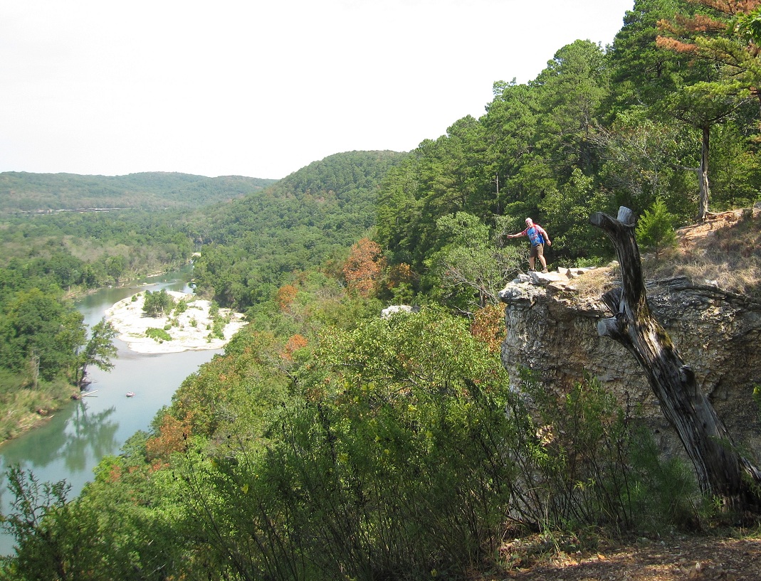
After a half mile, the trail ran right against a huge drop-off--and a series of bluffs. The views were amazing. I found a break in the trees and managed this pic.

I continued on, and the trail climbed.

Soon, I hit a very rocky section and it seemed that after this climb, I was out of trail. I did see where it seemed to head down down down--right to the edge. So, I followed.

Just before going over the edge, I was treated to a panoramic view that is why postcards were invented. As far as you could see, there was river, and distant horizons. WOW!!! Looking upstream--to the north....

and looking downstream to the south. I am guessing I was 200 feet above the river. I gave thought to throwing a rock out to see if I could hit the water, but the uneven footing seemed a bvit of a risk, so the rock idea was shelved.

I headed out, but not before taking a picture of his handsomeness, and making a video. Excuse the shakiness of the film. The wind was a bit strong, and I was on uneven ground. But the panorama is sweet.
From there, I headed on north. the trail was good, but there was nothing to top the bluffs. Doh!!! I ended up running almost right into a house with a fenced yard. A map check later shows me that had I went down the driveway of this house, I would be on a nice road that switchbacks down the side of a huge hill and leads right back to where the trail head is. Sounds like the makings of a good loop.